UPDATE 6:00 a.m. (Oct. 11): Hurricane Michael, which is now a tropical storm, continues to weaken over eastern Georgia.
Maximum sustained winds of 50 mph are increasing along portions of Georgia and South Carolina coasts, according to the National Hurricane Center.
Two deaths have been reported as a result of the storm.
A Florida Panhandle man was killed after a tree fell on his home, a Gasden County Sheriff’s Office spokeswoman told the Associated Press.
An 11-year-old child was killed when a tree fell onto a structure Thursday morning, according to a Seminole County EMA Director.
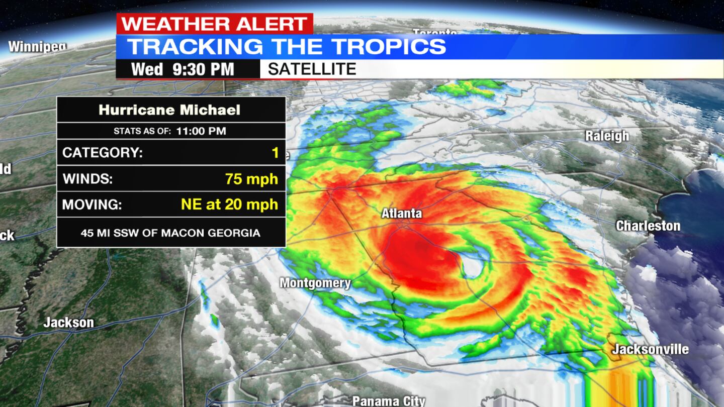
UPDATE @ 12:28 a.m. (Oct. 11): Hurricane Michael has weakened to a tropical storm as it moves across south-central Georgia, National Hurricane Center forecasters said Wednesday night. Storm flooding along the Gulf Coast is gradually decreasing. The storm, still a hurricane at 11 p.m., was moving northeast at 20 mph.
UPDATE @ 7:05 p.m.:
Hurricane Michael has led to at least one death.
>>LIVE UPDATES: "Extremely Dangerous" Hurricane Michael slams Florida coast
>> PHOTOS: Damage in Florida Panhandle
>>VIDEO: Has image of skull appeared on satellite image?
A Florida Panhandle man was killed after a tree fell on his home, a Gasden County Sheriff’s Office spokeswoman told the Associated Press.
Meanwhile, Florida Gov. Rick Scott said search and rescue teams are heading to the state’s hardest-hit areas to help survivors.
Hurricane Michael, which made landfall approaching a Category 5, is the strongest storm to hit the Florida Panhandle.
It is now slamming the Georgia coast.

UPDATE @ 5:10 p.m.:
Hurricane Michael is continuing to move inland and remains extremely dangerous with many different hazards. An extreme wind warning has been issued for parts of Florida, Georgia and Alabama. Current maximum sustained winds are at 125 m.p.h.
» RELATED: Ohio Task Force 1 activated for Hurricane Michael
UPDATE @ 4:11 p.m.:
The eye of Hurricane Michael is now approaching I-10 in Jackson County . Life threatening storm surge and catastrophic winds continue to cause damage across the Florida panhandle. Maximum sustained winds are at 140 mph.
UPDATE@ 3:10 p.m.:
The eye of Hurricane Michael has started to move inland over the Florida panhandle east of Panama City. Current maximum sustained winds are at 150 m.p.h.
UPDATE @ 1:41 p.m.:
Category 4 Hurricane Michael makes landfall near Mexico Beach, Florida, with 155 mph winds.
It is the first Cat 4 to hit the Florida Panhandle in recorded history.
UPDATE @ 1 p.m.:
Landfall is “imminent” for the strong Category 4 storm, which is about 15 miles from Mexico Beach, Florida.
Winds are sustained at 150 mph, with 89 mph wind gusts reported on the coast in Apalochicola, Fla., which also has seen more than 5½ feet of water over ground level.
Catastrophic storm surge, hurricane force winds will extend about 45 miles from center and tropical force winds, between 39 and 74 mph wind gusts will be possible 175 miles from the storm’s center.
UPDATE @ 12:14 p.m.:
Hurricane Michael is now a strong Category 4 storm with maximum sustained winds of 150 mph. The storm is now less than 40 miles away from land.
UPDATE @ 8:16 a.m.:
Hurricane Michael continues to strengthen as it approaches the Florida Panhandle. Michael now has maximum sustained winds of 145 mph.
UPDATE @ 7:04 a.m.: If Hurricane Michael makes landfall as a Category 4, it will be the first of its strength to do so in the Panhandle or Big Bend area of Florida since records began.
UPDATE @ 6:00 a.m (Oct. 10): Hurricane Michael has strengthened to an 'extremely dangerous' Category 4 storm, according to the National Hurricane Center.
Information collected from Hurricane Hunters and the Air Force Reserve aircrafts showed winds had picked up to 140 mph sustained, with some gusts measuring even higher.
Michael is still on track to move north/northeast today, eventually making landfall in the Florida Panhandle or Big Bend area. It will bring life threatening storm surge, hurricane force winds and flash flooding to the coast.
Michael will weaken over land as it bring heavy rain to states like Georgia, the Carolinas and possibly Virginia before heading back out into the Atlantic.
UPDATE @ 11:30 p.m.: Hurricane Michael most likely will make landfall about 8 a.m. Wednesday and could be a Category 4 storm by the time that happens, according to the National Hurricane Center.
Late Tuesday night, maximum sustained winds were 125 mph. The storm was continuing to move north at 12 mph. The eye was about 200 miles south-southwest of Panama City, Florida.
Life-threatening storm surge is likely along portions of the coasts of the Florida Panhandle, Big Bend and Nature Coast, where a storm surge warning is in effect.
“Everyone in the hurricane warning area along the Florida Gulf Coast should prepare for life-threatening major hurricane winds associated with the core of Michael,” center forecasters said.
Hurricane force winds also will extend well inland across portions of the panhandle, southern Georgia and southeast Alabama as the hurricane moves inland.
UPDATE @ 5:05 p.m.
Hurricane Michael has been upgraded to a Category 3 storm with sustained winds of 120 mph.
UPDATE @ 11:15 a.m.
Hurricane Michael continues to strengthen, and Storm Surge and Hurricane Warnings are in effect for portions of the Florida Gulf Coast. Maximum sustained winds have been measured at 110 mph and Michael remains a Category 2 storm.
UPDATE @ 8:08 a.m. (Oct. 9):
Hurricane Michael is now a Category 2 storm with sustained winds at 100 mph, according to the National Hurricane Center. The eye of the storm is becoming defined again, which is a sign of strengthening.
Tropical force winds extend 195 miles from the storm’s center.
HURRICANE MICHAEL: Wright-Patterson to house aircraft fleeing Florida ahead of storm
UPDATE @ 6:28 a.m.:
Hurricane Michael remains a Category 1 storm with 90 mph sustained winds. The storm will pull into the eastern Gulf of Mexico throughout the day.
Michael will make landfall in the Florida Panhandle or Big Bend area as soon as Wednesday. It’s expected to intensify to a Category 3 storm as wind shear weakens. Warm Gulf waters, which sit in the mid to upper 80s, will fuel the storm.
UPDATE @ 12:15 a.m. (Oct. 9): Residents of Florida's Panhandle filled sandbags, boarded homes and secured boats Monday in anticipation of the "monstrous storm" Hurricane Michael.
By 11 p.m. Monday, the storm’s top sustained winds had risen to 90 mph as it headed north at 12 mph. The storm was centered about 450 miles south of Apalachicola, Fla.
Before its expected landfall Wednesday, Michael could reach major hurricane status, forecasters said.
Florida Gov. Rick Scott declared a state of emergency for 35 counties from the Panhandle to Tampa Bay.
Scott also said state health officials are reaching out to hospitals and nursing homes to be prepared, the Associated Press reported. Hurricane Irma last year was blamed in 14 death when a South Florida nursing home lost power and air conditioning.
Scott delivered a blunt message to caregivers of the elderly and infirm: “If you’re responsible for a patient, you’re responsible for the patient. Take care of them.”
UPDATE @ 7:05 p.m.:
A state of emergency has been declared in Alabama.
Florida Gov. Rick Scott told the Associated Press the hurricane is a “monstrous storm” that has the potential to be devastating for the Florida Panhandle.
UPDATE @ 11:01 a.m. (Oct. 8)
Tropical Storm Michael was upgraded to a Category 1 hurricane just before 11 a.m. on Monday.
Located between the Yucatan Peninsula and Cuba, the hurricane is moving north into warm Gulf of Mexico waters.
As it does continue its trek north, we will likely see the hurricane rapidly intensify. The National Hurricane Center has forecast the storm to reach major hurricane status with winds topping out at more than 120 mph.
Hurricane watches are in effect for the Florida Panhandle and Big Bend as the storm is expected to make landfall Wednesday.
Storm surge, torrential rain, damaging winds, and tornadoes are all threats expected for the Sunshine State when Michael arrives.
INITIAL REPORT
Preparations have begun in states along the eastern Gulf Coast as Tropical Storm Michael moves closer.
Michael was situated on the western tip of Cuba, pounding the island with heavy wind and rain as of 8 a.m. Monday.
According to the National Hurricane Center, as Michael will strengthen quickly as it enters the Gulf of Mexico. It is projected to be nearing major hurricane status when it reaches the northeastern Gulf of Mexico on Tuesday night and into Wednesday.
Hurricane and tropical storm watches were issued from the Florida Panhandle into parts of Alabama on Monday morning. Early rainfall projections show areas within the Florida Panhandle into southern Georgia could receive between 4 to 8 inches of rain with some isolated pockets up to a foot.
Storm hazards include life-threatening flooding, storm surge and rip current.


